Below you will find pages that utilize the taxonomy term “Gps”
Postsread more
Hawaii Day 3
[caption id="" align=“aligncenter” width=“500” caption=“Newspaper Guy Reading the Newspaper, but ready to take photos with tourists”] 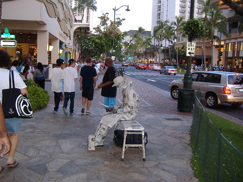 [/caption]
[caption id="" align=“alignleft” width=“180” caption=“This guy was just a block over from newspaper guy. He was also ready to take photos with tourists”] 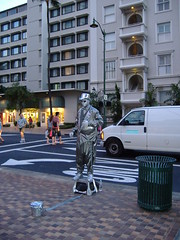 [/caption]
I think everyone has seen a street performer painted in metal and dressed in clothes with a metallic-looking surface. I’ve seen them in Miami, Vegas, and Fort Lauderdale. But only in Honolulu have I seen three of them on the same street only a block from each other. At first when I saw the guy in the newspaper clothing I thought that was pretty creative. But then I saw the metallic guy just a block over. And after that I saw the guy in the “ska” checker board suit. Definitely some points are due for them not all looking the same. But are there really that many people who want a photo with a metallic man that they will take three such photos?
Postsread more
Hawaii Day 2
[caption id="" align=“aligncenter” width=“500” caption=“The Quintessential Hawaii Scene: palm trees, the ocean, and surf boards”]  [/caption]
[caption id="" align=“alignleft” width=“240” caption=“Diamond Head from in the Ocean.”] 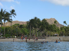 [/caption]
I forgot to mention, in my first post, that since I took all of my camera bodies and my GPS unit, I didn’t want to have to worry about setting it back to EST when I got back home, so I left everything in EST. So I decided to divide my days (for the purpose of these posts) as if it were in EST. So, on Day 2 I continued to take pictures as I walked about. But I also tried out the new underwater housing I bought for Danielle’s camera. It was pretty awesome being able to have the camera with me in the water. I was able to get some photos underwater and, if Danielle had been with me, we could have taken portraits of each other in the water. Nearly all of my photos from that day were with the underwater housing and here is a sampling of those photos.
Postsread more
Flickr Stuff
Unfortunately, the flickr map page for my account only shows the last 30 or so photos on the map. So it’s pretty rare to get it zoomed out this far to show your GPS shots. I keep wishing they’d show all the GPS tagged photos (using some algorithm to combine them into one dot if you’re zoomed out far enough) so you can get an idea of where around the world the users have been. So after uploading a few Hawaii photos, it looked like this:
Postsread more
Tutorial: Geo-Tagging Your Photos
[caption id="" align=“aligncenter” width=“500” caption=“Some of the equipment you need to geo-tag your photos.”] 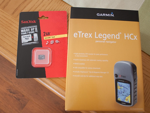 [/caption]
Recently I was listening to The Command Line Podcast and the host mentioned one way to help others is to write up a tutorial on your blog whenever you learn a new skill or task. Since the information I needed for geo-tagging my photos was fragmented, I decided to write up a tutorial following my workflow. I’ll break this up into the different phases involved.